
Image: New Zealand Hop Growing Regions Map – Nelson and Motueka
Published: October 1, 2026 at 4:38:59 PM UTC
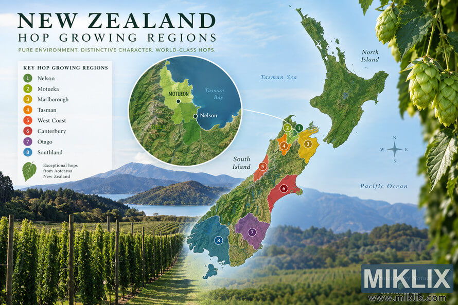
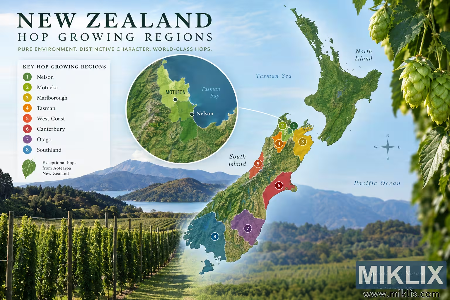
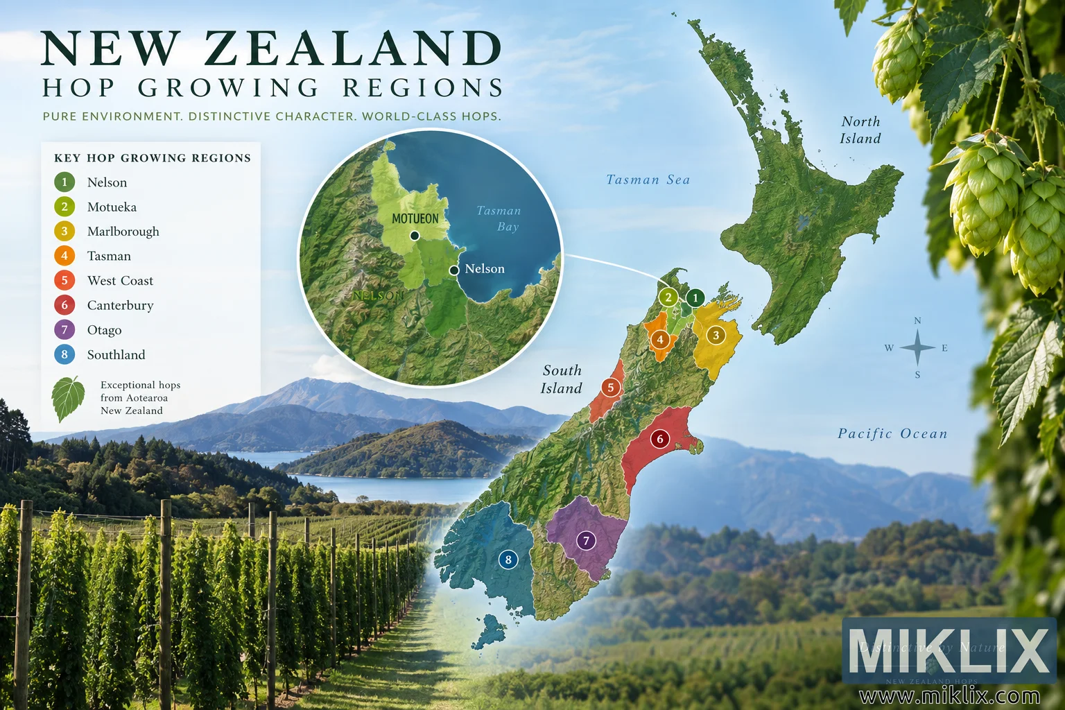
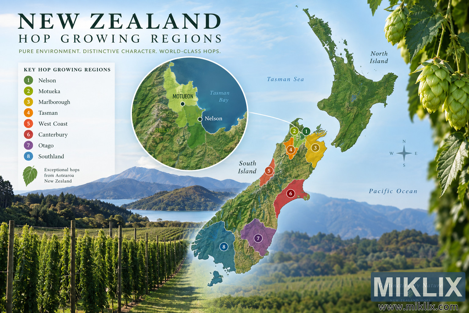
Explore a landscape infographic of New Zealand hop-growing regions, with special focus on Nelson and Motueka near Tasman Bay, alongside hop fields and regional map markers.
Available versions of this image
The image files available for download below are less compressed and higher resolution - and as a result of that, higher quality - than the images embedded in articles and pages on this website, which are more optimized for file size in order to reduce bandwidth consumption.
Regular size (1,536 x 1,024)
Large size (3,072 x 2,048)
Very large size (4,608 x 3,072)
Extra large size (6,144 x 4,096)
Comically large size (1,048,576 x 699,051)
- Still uploading... ;-)
Image description
A wide, landscape-oriented infographic presents a visually rich map of New Zealand in the context of hop cultivation. The composition combines cartographic information, agricultural scenery, hop plants, typography, and a magnified regional inset. The overall palette is dominated by natural greens, blues, earthy browns, and warm regional accent colors, giving the image an agricultural and geographic character. Across the upper left, a large serif headline reads “NEW ZEALAND,” with the smaller heading “HOP GROWING REGIONS” directly beneath it. Below the heading is the line “PURE ENVIRONMENT. DISTINCTIVE CHARACTER. WORLD-CLASS HOPS.” The central and right portions of the image are occupied by a relief-style map of New Zealand. The North Island appears toward the upper right and is rendered primarily in natural green terrain tones. The South Island extends diagonally from the upper center toward the lower center of the composition. Surrounding ocean areas are pale blue, with the Tasman Sea labeled to the west and the Pacific Ocean labeled to the east. The North Island and South Island are also identified with italic labels. A compass rose appears to the right of the South Island, indicating north, south, east, and west.
The South Island map is divided into several highlighted areas intended to identify hop-growing regions. These areas are distinguished using colored overlays and numbered circular markers. A legend positioned on the left is titled “KEY HOP GROWING REGIONS.” It lists eight numbered entries: 1 Nelson, 2 Motueka, 3 Marlborough, 4 Tasman, 5 West Coast, 6 Canterbury, 7 Otago, and 8 Southland. Each number is shown inside a colored circle corresponding to a colored region on the South Island map. Nelson is represented in green, Motueka in yellow-green, Marlborough in golden yellow, Tasman in orange, West Coast in reddish orange, Canterbury in red, Otago in purple, and Southland in blue. Beneath the list is a stylized green hop leaf and the wording “Exceptional hops from Aotearoa New Zealand.” The highlighted regions create an immediately visible geographic overview, although the infographic should be understood as a decorative visualization rather than a precise authoritative map of commercial hop acreage.
A large circular magnifying inset occupies the upper-left-center portion of the composition and focuses on the northern part of the South Island around Tasman Bay. It is connected visually to the corresponding area of the main map by a thin white line. The inset uses shaded terrain imagery, with mountainous landforms in darker greens and browns and the coastal plain shown in brighter green. Tasman Bay is rendered in deep blue. Nelson is marked near the southeastern side of the bay with a dark circular location point and a white outline. A second location point farther northwest is intended to indicate Motueka, although the generated lettering at that point appears slightly distorted and does not perfectly reproduce the place name. The inset emphasizes the Nelson–Motueka area as the principal geographic focus of the infographic and makes these two locations more prominent than the other regions shown in the legend.
Agricultural photography is integrated into the cartographic design. Along the bottom left, rows of tall cultivated hop plants extend into the distance on upright poles and trellises. Sunlight illuminates the green foliage, while mountains, wooded hills, and a body of water form the background. This landscape imagery blends gradually into the lower portion of the illustrated map, creating a collage-like transition between real-world agriculture and geographic visualization. Across the bottom right, a softly focused rural landscape continues the natural setting with green fields, wooded hills, and distant blue-gray mountains. The atmospheric perspective gives the composition depth while keeping the central map visually dominant.
On the far right edge and upper-right corner, large hop vines frame the infographic. Several clusters of pale green hop cones hang from stems surrounded by broad, serrated green leaves. The hop cones are brightly lit and detailed, reinforcing the subject without depicting any commercial packaging or identifiable product branding. The foliage partly overlaps the blue sky and acts as a natural visual border. The combination of hop cones, trellised crops, and regional mapping makes the agricultural theme recognizable even before the viewer reads the labels.
The design uses a bright blue sky with soft white clouds as much of its background. Terrain on the map is rendered with relief-like texture, suggesting mountain ranges, valleys, forests, and coastal features. The colorful regional overlays remain partially integrated with this topographic texture rather than appearing as completely flat shapes. Numbered circles are placed over their corresponding areas and use white numerals for contrast. The visual hierarchy leads from the large New Zealand heading to the map, then to the circular Nelson–Motueka inset and the legend, with the hop photography providing contextual framing.
Near the lower right, an italic phrase reads “Distinctive by Nature,” accompanied by a thin horizontal line and small decorative text below. The image contains no actual commercial logos or recognizable third-party brand marks. Its presentation resembles a premium agricultural or tourism infographic, with editorial-style serif typography, fine map labeling, and scenic imagery. The primary informational message is that New Zealand has multiple highlighted hop-growing areas, with particular emphasis placed on Nelson and Motueka at the northern end of the South Island. The map provides broad visual context for those locations while the circular inset gives a closer view of their relationship to Tasman Bay and the surrounding terrain. Overall, the image communicates a connection between New Zealand’s geography, temperate green landscapes, and hop cultivation through a polished combination of map graphics and photographic agricultural scenery.
The image is related to: Hops in Beer Brewing: Green Bullet